Kisakata and Mt. Chokai guide
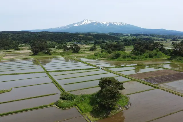
Kisakata, visited by Basho on his Narrow Road to the Deep North, is a land of rice fields dotted with little pine islands. At the foot of Mt. Chokai, spring water filtered through lava pours out as waterfalls.
Things to see 3 classics
"Classics", "For visitors" and "Local picks" are this site's editorial picks, not a measured popularity ranking.
- 1
Kisakata Kujukushima (the Ninety-nine Islands)
Once islets in a lagoon, lifted by an Edo-period earthquake. Pine-topped mounds now rise from rice fields.
- Nature
- Views
- History & buildings
about 45 minFree
Walk · About 10 min from Kisakata ・ 700m
- 2
Kanmanji Temple
An old temple on one of Kisakata's former islands, visited by Basho, with a stone bearing his haiku and relics of the old lagoon view.
- Temples, shrines & churches
- History & buildings
about 45 minPaid entry
Walk · About 15 min from Kisakata ・ 1.0km
- 3
Mototaki Spring Falls
Water that has seeped through Mt. Chokai's lava pours across a mossy rock face about 30 m wide.
- Nature
- Views
about 45 minFree
Taxi · About 15 min from Kisakata ・ Taxi from Kisakata Station, then about 15 minutes on foot from the parking area ・ 6.6km
Show on map
ClassicsFor visitorsLocal picks
Suggested routes
Times assume a 9:00 start. Travel times are estimated from distance and vary with waiting and crowds.
Basho's Kisakata on foot
Leave 9:00 → until about 13:34 (about 4.5 hr)
- 9:00Kisakata
about 10 min on foot
9:10Kisakata Local History Museumstay about 45 minabout 20 min on foot
10:15Kisakata Kujukushima (the Ninety-nine Islands)stay about 45 minabout 11 min on foot
11:11Kanmanji Templestay about 45 minabout 8 min on foot
12:04Michi-no-Eki Kisakata Nemunookastay about 1.5 hr
Learn what the old lagoon looked like at the museum, then walk among the rice-field islands to Kanmanji, ending with a sea-view bath at the roadside station.
Plan this routeMt. Chokai's springs and waterfalls
Leave 9:00 → until about 13:05 (about 4 hr)
- 9:00Kisakata
about 10 min by transport
9:10Naso no Shirataki Fallsstay about 30 minabout 15 min by transport
9:55Mototaki Spring Fallsstay about 45 minabout 25 min by transport
11:05Shishigahana Wetlandstay about 2 hr
Go by taxi. Shishigahana Wetland can be walked from spring to autumn, not in the snow season.
Plan this route
Main ways to get around
Limited Express Inaho
About 50 minutes from Akita to Kisakata and 3 hours from Niigata, also stopping at Ugo-Honjo and Nikaho.
JR Uetsu Line local trains
About 1 hour 10 minutes from Akita to Kisakata. South of Kisakata toward Sakata, trains are very few.
Taxis from Kisakata Station
About 10 to 15 minutes to Naso Falls and Mototaki. Hokodate on Mt. Chokai is about 45 minutes; the road closes in winter.
Yuri Kogen Railway (Chokai Sanroku Line)
A rural line from Ugo-Honjo to Yashima with views of Mt. Chokai.
Getting to Kisakata
“Classics”, “For visitors” and “Local picks” are our editors' picks, not a measured popularity ranking. Travel times are estimates. Please check prices, opening hours and operating days with the official sources before you go.
Local food specialties
Specialties of Kisakata and Mt. Chokai, together with those of other places in Akita. They are listed by dish, not by shop, and are not recommendations.
Seafood
Kisakata iwagaki (summer rock oysters)
象潟の岩ガキ
Rock oysters grown in waters fed by Mt. Chokai's underground water. In season from early June to late August.
- Known in
- Kisakata
Hot pots & soups
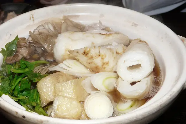
Kiritanpo nabe (hot pot with grilled rice sticks and Hinai chicken broth)
きりたんぽ鍋
Hot pot of kiritanpo rice sticks and plenty of vegetables simmered in soy-based Hinai chicken broth.
- Known in
- Odate · Odate, Kosaka and Ani guide
Noodles
Inaniwa udon (thin, smooth hand-stretched udon)
稲庭うどん
Udon presented as an Akita local dish, firm in texture and smooth to swallow.
- Known in
- Yuzawa · Yokote, Masuda and Yuzawa guide
Noodles
Yokote yakisoba (fried noodles topped with a sunny-side-up egg)
横手やきそば
Yakisoba made with Yokote-made boiled noodles, topped with a soft fried egg and pickles. The yolk is mixed into the noodles.
- Known in
- Yokote · Yokote, Masuda and Yuzawa guide
Hot pots & soups
Oga ishiyaki ryori (seafood stew cooked with a red-hot stone)
男鹿の石焼き料理
A local dish of Oga seafood and stock in a cedar tub, cooked instantly by dropping in a red-hot stone.
- Known in
- Oga · Oga Peninsula guide
Hot pots & soups
Shottsuru nabe (hot pot flavored with salted hatahata fish sauce)
しょっつる鍋
A hot pot made with hatahata (sailfin sandfish), Akita's signature fish, listed as a local dish of Akita City.
- Known in
- Akita City · Akita City guide
“Find places serving it” opens a map app search for the dish name and the place name. The results are not chosen or recommended by this site. Please check with the shop whether it serves the dish.
Traditional home dishes of Akita (29)Practical booking & planning links (Ad)
- Activities, tickets & local tours
- Popular observatories, museums and theme parks increasingly require timed-entry tickets booked in advance. For countryside spots with infrequent buses, a local day tour can save hours.
- KlookKKday
- Rental cars
- A rental car is practical when travelling straight from an airport or exploring rural areas with few trains. Request child seats, an ETC toll card, or winter snow tyres when booking.
- Klook
- Restaurant reservations & food tours
- Well-known dinner spots and course restaurants often fill up days ahead—reserving a table saves waiting in line. Guided local food tours are also a great way to try regional dishes.
- Klook
We list only well-established booking services. This site may receive a commission if you book through these links (each opens in a new tab).
Comment on whether your booking was helpful
Sources
Local food specialties
Each specialty was checked against an official page (prefecture, municipality, tourism association or JNTO) on 2026-11-17. The descriptions were written by this site.
- Kisakata iwagaki (summer rock oysters): nikaho-kanko.jp
- Kiritanpo nabe (hot pot with grilled rice sticks and Hinai chicken broth): www.pref.akita.lg.jp
- Inaniwa udon (thin, smooth hand-stretched udon): www.pref.akita.lg.jp
- Yokote yakisoba (fried noodles topped with a sunny-side-up egg): www.city.yokote.lg.jp
- Oga ishiyaki ryori (seafood stew cooked with a red-hot stone): www.city.oga.akita.jp
- Shottsuru nabe (hot pot flavored with salted hatahata fish sauce): www.city.akita.lg.jp
Photo and data credits
Mt. Chokai rising beyond flooded rice paddies らんで (CC BY 4.0) / Kiritanpo hot pot with grilled rice sticks, maitake and seri greens Chensiyuan (CC BY-SA 4.0). Cropped and resized.