Daisen-ji大山寺
Mt. Daisen guide
Mt. Daisen, the highest peak in the Chugoku region. Climb from the old temple approach to the summit, then visit a beech-forest pass, a dairy farm, a highland lift and a photography museum below.
Things to see 2 classics
"Classics", "For visitors" and "Local picks" are this site's editorial picks, not a measured popularity ranking.
By interest
By how you get there
By distance
- 1
Daisen summit trail (Misen)
The main trail from near Daisen-ji to the 1,709 m summit of Misen. Boardwalks cross the top; on clear days you see the Sea of Japan.
- Activities
- Nature
- Views
about 5 hrFree
Walk · About 10 min from Daisen-ji ・ About 10 minutes on foot from the Daisen-ji bus stop to the trailhead ・ 2.8km
- 2
Kagikake Pass
A pass facing the sheer southern wall of Mt. Daisen, above a beech forest that glows with color in autumn.
- Views
- Nature
about 30 minFree
Taxi · About 20 min from Daisen-ji ・ About 20 minutes by car from Daisen-ji on the ring road ・ 5.7km
Show on map
ClassicsFor visitorsLocal picks
Suggested routes
Times assume a 9:00 start. Travel times are estimated from distance and vary with waiting and crowds.
Around Daisen-ji Temple
Leave 9:00 → until about 13:15 (about 4.5 hr)
- 9:00Daisen-ji
about 2 min on foot
9:02Daisen Nature and History Museumstay about 30 minabout 6 min on foot
9:38Mt. Daisen (Daisen-ji and Ogamiyama Shrine Okumiya)stay about 3 hrabout 7 min on foot
12:45Daisen-ji Amida Hallstay about 30 min
Learn about the mountain at the museum, then follow the stone-paved approach to the temple and shrine. The Amida Hall stands in a cedar wood.
Main ways to get around
Local bus (Yonago Station – Daisen-ji)
About 50 minutes on the Nihon Kotsu bus from stop 5 at Yonago Station. It gets crowded on weekends and in ski season, so queue early.
Rental car or taxi
Buses barely reach the Kagikake Pass, Masumizu, Kagamiganaru or the dairy farm, so a car is easiest. Winter tires are needed in snow season.
JR Hakubi Line (Kishimoto, Ebi)
Runs along the western and southern foot of Daisen. Kishimoto is the nearest station for the Shoji Ueda Museum of Photography.
Getting to Daisen-ji
“Classics”, “For visitors” and “Local picks” are our editors' picks, not a measured popularity ranking. Travel times are estimates. Please check prices, opening hours and operating days with the official sources before you go.
Photo and data credits
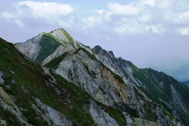
The ridge near the summit of Mt. Daisen Mass Ave 975 at English Wikipedia (CC BY-SA 3.0). Cropped and resized.
Connections from here
Everything you can branch out to from here, on one map. Tap any item to open it.
Daisen-ji
Area guide
Within walking distance
Facilities & features
- Elevators available (the route may be longer)
Lines from here
Within walking distance of here
See nearby on a mapWalking times are estimates from the straight-line distance.
- Go hereDaisen Nature and History MuseumAbout 1 min on foot
A free prefectural museum on Daisen's nature and its history as a sacred mountain, with up-to-date trail information.
- Go hereMt. Daisen (Daisen-ji and Ogamiyama Shrine Okumiya)About 6 min on foot
A 1,709-meter volcanic peak. Daisen-ji Temple and the inner shrine of Ogamiyama Shrine stand partway up.
Sights are this site's picks, not a popularity ranking.
Tips for this place
Write a tipNo tips match these filters yet.
Questions about this place
Ask a questionNo questions yet. Ask about getting here, tickets or luggage.
Practical booking & planning links (Ad)
We list only well-established booking services. This site may receive a commission if you book through these links (each opens in a new tab).