Katakuradai Elementary School West片倉台小学校西
다카오산・하치오지 가이드
A mountain on Tokyo's western edge, about an hour by train from Shinjuku. Ride the cable car halfway, walk past Yakuo-in Temple to the summit, then soak in the hot spring by the station afterward.
볼거리 대표 2곳
'대표 명소', '여행자 체험', '현지 추천'은 이 사이트의 편집부가 고른 것이며, 인기 순위를 조사한 것이 아닙니다.
관심사로 고르기
이동 수단으로 고르기
거리로 고르기
- 2
다카오산 정상
The 599-meter summit. On clear days you can see Mt. Fuji to the west and central Tokyo and the bay to the east.
- 경치·전망
- 자연
약 45분무료
로프웨이 · Takaosanguchi에서 약 60분 ・ Cable car to Takaosan Station, then about 40 minutes on foot along Trail 1 ・ 여기서 9.3km
'대표', '여행자 체험', '현지 추천'은 이 사이트 편집자가 고른 것이며, 인기 순위를 조사한 것이 아닙니다. 소요 시간은 기준입니다. 요금·영업시간·운행일은 출발 전에 공식 안내를 확인해 주세요.
사진·데이터 출처
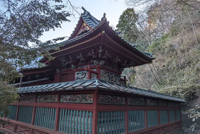
A red-lacquered shrine hall on Mount Takao Syced (CC0). 잘라내고 축소했습니다.
시설·특징
- 엘리베이터 있음(돌아가야 할 수 있음)
- 환승 예상 시간 약 4분
여기서 탈 수 있는 노선
- Keio Bus 北10 (Kitano Sta. North → Seibu kitanodai)
- Keio Bus 北10 (Seibu kitanodai → Kitano Sta. North)
- Keio Bus 八65 (Hachioji Sta. South → Katakuradai)
- Keio Bus 八65 (Katakuradai → Hachioji Sta. South)
- Keio Bus 北06 (Kitano Sta. South → Hachioji-minamino Sta.)
- Keio Bus 北06 (Hachioji-minamino Sta. → Kitano Sta. South)
- Keio Bus 八69 (Hachioji Sta. South → Hachioji-minamino Sta.)
- Keio Bus 八69 (Hachioji-minamino Sta. → Hachioji Sta. South)
이 장소의 후기
후기 쓰기조건에 맞는 후기가 아직 없습니다.
이 장소에 대한 질문
질문하기아직 질문이 없습니다. 가는 법, 승차권, 짐에 대해 물어보세요.
주변 장소
여행 준비·예약할 수 있는 사이트(광고)
신뢰할 수 있는 대형 예약 서비스만 안내합니다. 링크를 통해 예약이 이루어지면 이 사이트가 소개료를 받을 수 있습니다(새 탭에서 열림).